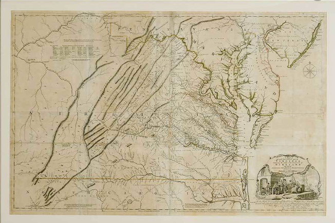
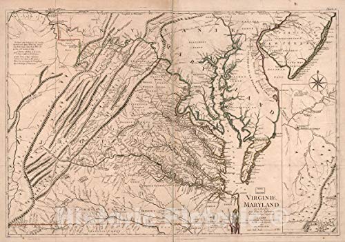
The Fry-Jefferson Map
The Fry-Jefferson Map was one of the most important surveys of the 18th century.
The map was complete by Joseph Fry and Peter Jefferson, father of a future President.
It was completed in 1752, which is a bit earlier than we usually discuss here, but its effect on the Founders was extremely important so we’ll give it a pass.
Joshua Fry
Oxford Educated Joshua Fry moved to Virginia as a young man and took up a position as a Professor of Mathematics at the College of William and Mary.
Fry quickly became an important leader of the colony, receiving an appointment as Commander-in-Chief of the Virginia Militia.
Additionally, he was given the task of completing several surveys. It was under this condition that he began working with Peter Jefferson.
Peter Jefferson
Peter Jefferson was a frontier surveyor in Virginia.
Although his son, Thomas, would later write the Declaration of Independence, Peter had little formal schooling.
However, hard work and tenacity allowed him to prosper and he was asked by Joshua Fry to create a map of the Northern Neck of Virginia.
Outlining Virginia
The two men realized they were great coworkers and joined forces again to clarify the border between Virginia and North Carolina.
This was a dangerous task. They had to fight off animals throughout the trip and usually slept in trees so as not to be taken by surprise.
The Royal Governor was so impressed with the job the surveyors had done that in 1750 he gave them a much larger quest...to map out the entire colony of Virginia.
The Fry-Jefferson Map
The result of the Governor’s request was the Fry-Jefferson map.
This landmark document was by far the most detailed map of Virginia in the 18th century.
It would be useful to both travelers and soldiers during the French and Indian War as well as the Revolutionary War.
Unfortunately, the two men were not long for this world, as Fry would die after falling from a horse and Jefferson passing away just a few years later.
Legacy
Joshua Fry’s death would leave vacant his command of the Virginia Regiment, a position which would immediately pass on to a very young George Washington (who would later use this map while at war).
Peter Jefferson’s legacy would pass through his son, Thomas.
Thomas Jefferson inherited not just land and wealth from his father, but many of Fry’s surveying instruments as well.
Unfortunately, the original map was lost in the 1770 fire at Jefferson’s Shadwell, but the work of Joshua Fry and Peter Jefferson would directly affect the career paths of two of the first three Presidents of the United States of America.
Do you want to read about other IMPORTANT DOCUMENTS of the 18th century?
Here you go:
Poor Richard’s Hoax - Making Ben Franklin Famous
George Washington and the Rules of Civility
Thomas Jefferson Makes a Name for Himself (A Summary View)
Do you want a copy of this great map to hang in your house?
Here is a nice large copy that will fit great in any rustic style room.
Pick it up through the Amazon affiliate link below:
If you are new to this site, make sure you subscribe to our email list for a new Founder every day.